boydsmaps
Boyd's Map of the Pines 2020
© 2020 Boyd Ostroff
Data Source
This map is locally hosted at boydsmaps.com
Link to this metadata:
boydsmaps.com/mapinfo/pines2020.html
Link to this map:
boydsmaps.com/#17.00/39.749970/-74.584850/pines2020/0.00/0.00
Originally published:
November 24, 2020
Most recent update:
none
Resolution:
4 feet (1.2 meters)
Map Tiles:
520,000
Size:
5.93 gb
Description
This map is the newest in the "Map of the Pines" series which dates back to 2008 and is a major update to Boyds Map of the Pines HD from 2017. The list of new features includes:
Almost 1.8 million buildings from Microsofts US Building Footprint dataset, providing complete coverage throughout the region
More than 1.4 million New Jersey tax parcel boundaries from 2020 data
Over 4,400 historical building locations, hand-traced from vintage aerial imagery and topographic maps
Almost 2,500 miles of HD unpaved roads, hand-traced from aerial imagery and USGS 24k topo maps
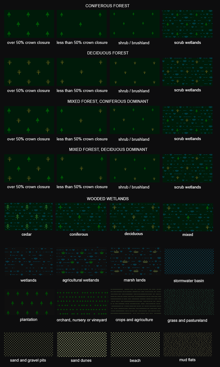
Unique new landcover includes graphic representations of forests, crops, marshes, bogs, beaches, gravel pits and more
New contour lines with 5-foot intervals, created from 2020 USGS 3DEP 1/3 arc-second (10-meter) DEM
More historical towns and points of interest from vintage topographic maps
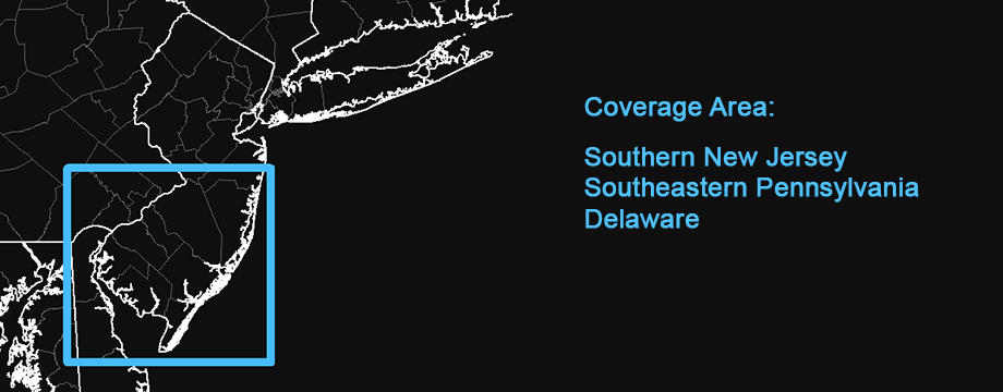
Extended coverage North to Interstate 195, adding about 370 square miles to the map
New map-making workflow with less image compression provides enhanced clarity and less distortion
New features from 2020 NJDEP data:
Greatly expanded openspace
Over 300 miles of hiking trails
Parking areas, boat launches, picnic areas, campsites and restrooms
NJ Natural Heritage Priority Sites
Solar power facilities
Earthquake epicenters
Landfill locations
Landcover Types (These features are only visible at zoom levels 15, 16 and 17)
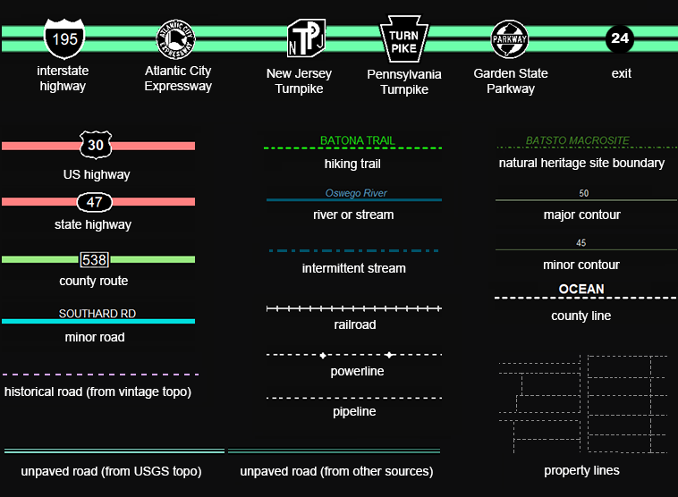
Line Types (appearance may vary, depending on zoom level)
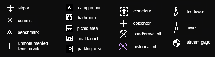
Point Types (appearance may vary, depending on zoom level)
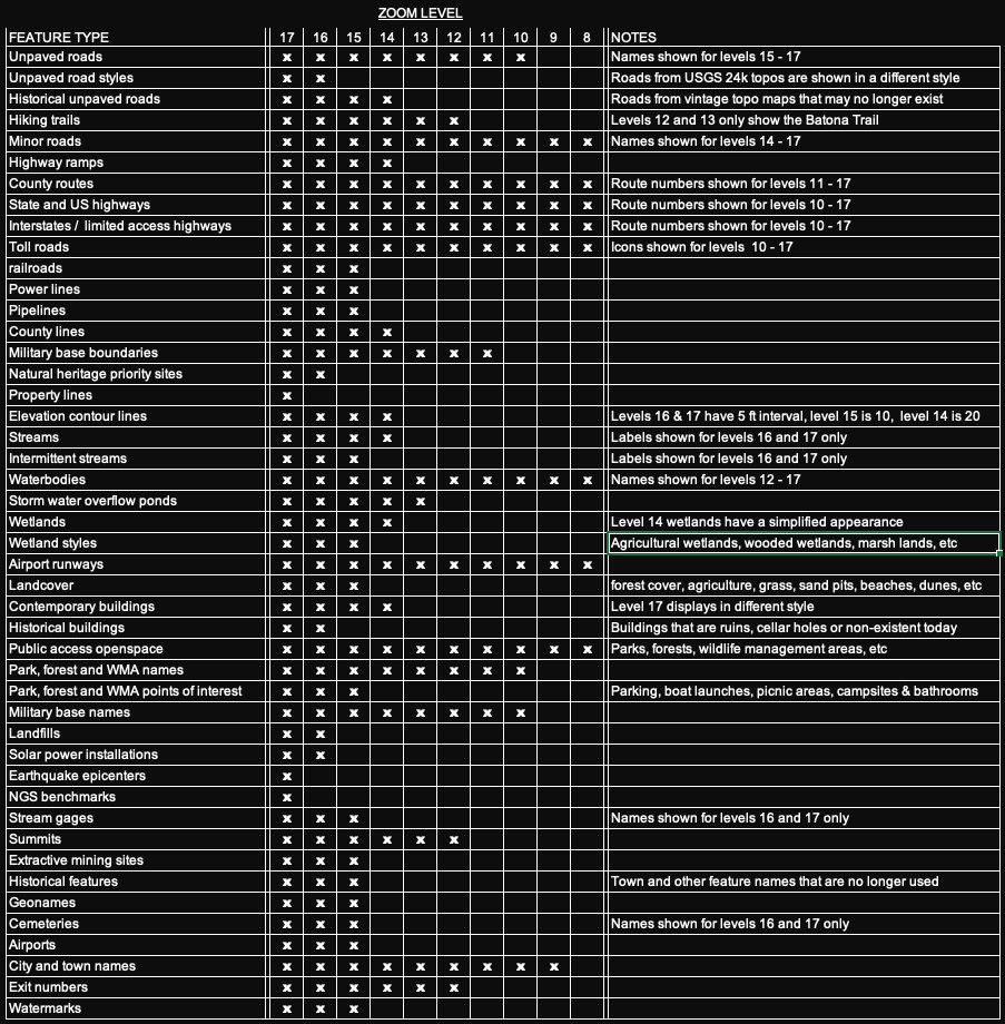
Not all map features are shown on every zoom level. An "x" in the zoom level column indicates the feature will be displayed.
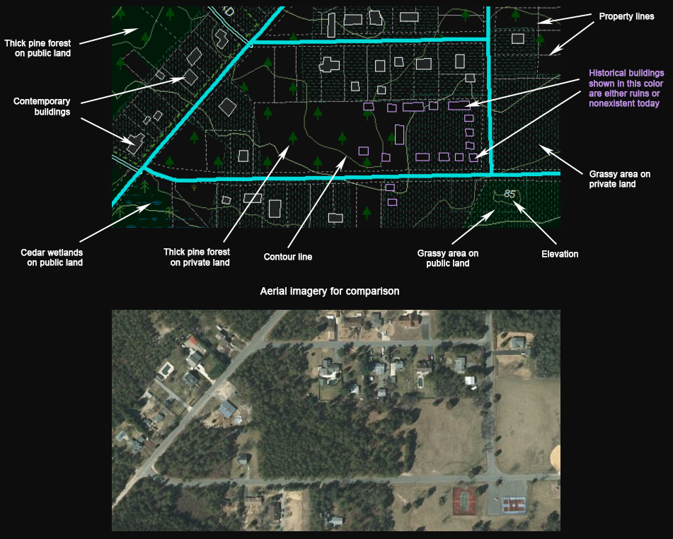
Understanding the Map: buildings and property lines
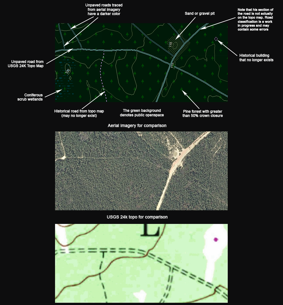
Understanding the Map: different styles of unpaved roads
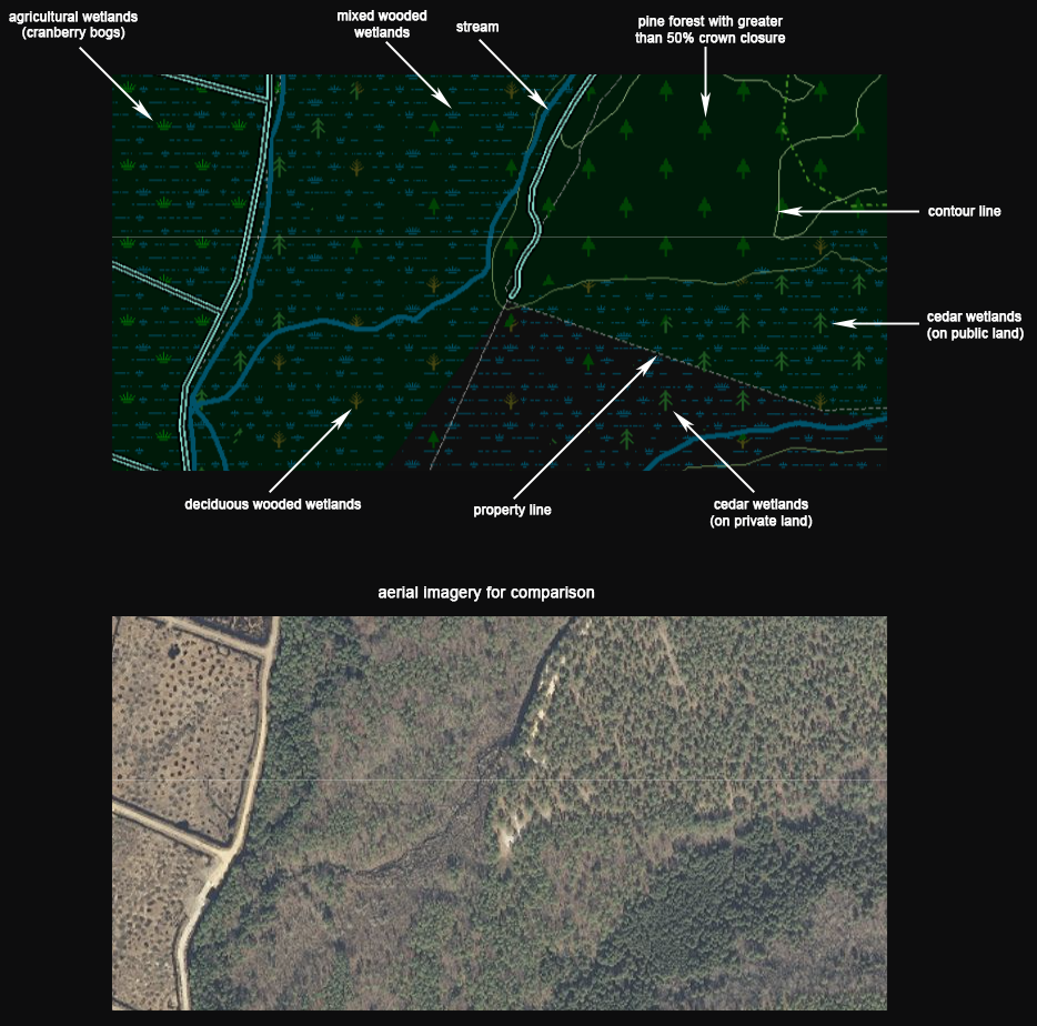
Understanding the Map: the forest and wetlands
Natural Heritage Priority Sites
These sites have been identified by the Office of Natural Lands Management as critically important areas to conserve New Jersey's biological diversity that should be considered as top priorities for preservation.
Credits
Transportation
New Jersey paved roads from the NJ Dept of Transportation
Route number icons and highway exit numbers created by the author
Pennsylvania, Delaware and Maryland roads based on OpenStreetMap data
HD unpaved New Jersey roads were hand-traced by the author from aerial imagery, historical topo maps and USGS LIDAR imagery
Hiking trails from 2020 NJDEP data, the author's personal data and other sources
Railroads from US Census Bureau TIGER shapefiles and OpenStreetMap
Public Openspace
New Jersey Department of Environmental Protection
Pennsylvania Geospatial Data Clearinghouse
Delaware FirstMap Data
Maryland iMap GIS Data Portal
National Park Service
Hydrography
Waterbodies, rivers, streams and wetlands from the USGS National Hydrography Dataset
Hew Jersey waterbodies and wetlands from the NJDEP 2012 land use/landcover dataset
Waterbody names from USGS GNIS, the USGS National Hydrography Dataset and other sources
Stream gage locations from the USGS and NJDEP
Structures
11,898 buildings hand-traced from aerial imagery by the author
1,180 buildings from OpenStreetMap
1,775,421 buildings from the Microsoft US Building Footprint project at GitHub
4,419 historical buildings hand-traced by the author from vintage topo maps and aerial imagery
Land Use/Land Cover
The graphical representation of forest cover was created by the author
NJDEP 2012 landcover/land use dataset
Maryland iMap 2010 landcover/land use dataset
Delaware FirstMap 2007 landcover/land use dataset
National Land Cover Dataset 2011 Landsat imagery from the MRLC Consortium
Elevation
Contour lines created from USGS 3DEP 2020 1/3 arc-second (10-meter) Digital Elevation Model (DEM)
Other
Placenames, geonames, airports, summits, towers and other point data from the USGS GNIS system
Bathrooms, boat launches, parking areas, campsite and picnic areas from 2020 NJDEP data
Landfills, solar farms, and earthquake epicenters from 2020 NJDEP data
Natural heritage priority site boundaries from 2020 NJDEP data
Extractive mining locations from the New Jersey Dept of Environmental Protection
Historical point features from historical topographics maps
Military base boundaries created by the author from tax parcel data
Benchmark locations from the National Geodetic Survey
Property lines created from 2020 NJGIN tax parcel shapefiles
Airport runways hand-traced by the author from aerial imagery
Pennsylvania, Delaware and Maryland powerlines and pipelines from US Census Bureau TIGER shapefiles and OpenStreetMap
New Jersey powerlines and pipelines were hand-traced by the author from USGS 24k topo maps and NJGIN aerial imagery
Distribution Liability
Map software is provided "as is", without any express or implied warranty. In no event will boydsmaps.com be held liable for any damages arising from the use of this software. The user assumes all risks associated with the use of this software. boydsmaps.com will not be held responsible for any inaccuracies and no responsibility is assumed for damages or other liabilities due to errors, installation, accuracy, availability, use or misuse of the data presented.
The user should not assume they are permitted to drive or walk on a road or trail just because it appears on this map. Some of the roads and trails shown may be on private property or may have regulations prohibiting vehicular or other use. Some roads may not be passable and could be dangerous. It is the sole responsibility of the user to determine the suitability of any road shown on this map.
Boundaries shown for parcels, openspace and military installations are approximate and may contain significant errors. Some areas indicated as openspace may be not be open to access by the general public. It is the responsibility of the user to independently determine if they are permitted in these areas.
This map contains NJDEP Bureau of GIS digital data but has not been verified by NJDEP and is not state-authorized.