Southern New Jersey 1970's Monochrome Aerial Imagery
© 2025 Boyd Ostroff
This map is hosted locally at boydsmaps.com
Link to this metadata:
boydsmaps.com/mapinfo/pines2023.html
Link to this map:
boydsmaps.com/#15.00/39.751172/-74.585064/pines1970/0.00/0.00
Originally published:
February 12, 2025
Most recent update:
none
Resolution:
4 feet (1.2 meters)
Map Tiles:
522,000
Size:
3.72 gb
Imagery Data Sources
Delaware Valley Regional Planning Commission (DVRPC)
1970 Historical Aerial Imagery
www.dvrpc.org/aerials/
NJ Office of Information Technology, Office of Geographic Information Systems
New Jersey 1970 Wetlands Imagery
newjersey.maps.arcgis.com/home/item.html?id=
NJ Office of Information Technology, Office of Geographic Information Systems
New Jersey 1977 Tidelands Imagery
newjersey.maps.arcgis.com/home/item.html?id=
Delaware Department of Technology and Information
1968 USDA Agricultural Stabilization and Conservation Service Aerial Photography
imagery.firstmap.delaware.gov/imagery/rest/services/
Atlantic County New Jersey, Office of GIS
1970 Aerial View of Atlantic County, New Jersey
acogis.maps.arcgis.com/home/item.html?id=
Rutgers University Community Repository (RUcore)
NJ Department of Enivronmental Protection Aerial Photographs Collection
1972 Millville, New Jersey Aerial Photograph
rucore.libraries.rutgers.edu/rutgers-lib/20503/
Basemap Data Sources
NJ Office of Information Technology, Office of Geographic Information Systems
Land Use/Land Cover of New Jersey 1986
www.arcgis.com/home/item.html?id=
US Geological Survey
Enhanced Historical Land-Use and Land-Cover Data Sets
pubs.usgs.gov/ds/2006/240/
New Jersey paved roads from the NJ Dept of Transportation and boydsmaps proprietary data
Pennsylvania and Delaware roads based on OpenStreetMap data
Unpaved roads from the USGS and other sources, including boydsmaps proprietary data
Description
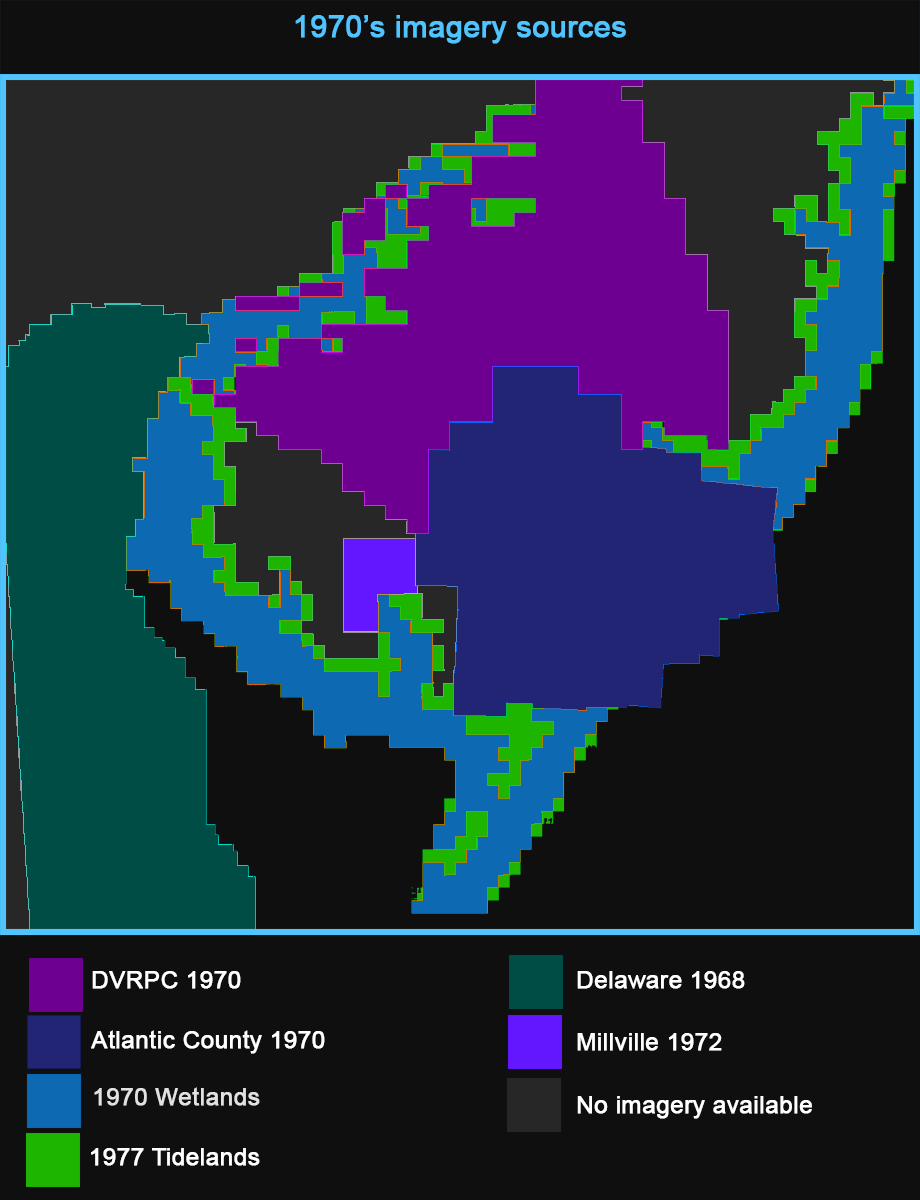
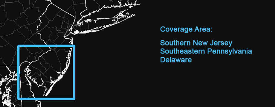
This boydsmaps-exclusive map is a mosaic of aerial imagery from the 1970's covering Southern New Jersey and Delaware. Unfortunately, there is no available imagery for Pennsylvania and portions Ocean, Cumberland and Salem Counties in New Jersey. A simple monochromatic basemap with roads, waterbodies and shaded landcover is shown for these areas.
Where available, the New Jersey 1970 Wetlands imagery has been used. These aerials cover the coastal areas and were captured primarily during 1971-72 to support the Wetlands Act of 1970 (NJSA 13:9A-1, ET SEQ)
The New Jersey 1977 Tidelands imagery is used in coastal areas not covered by the 1970 Tidelands imagery. The NJ 1977 tidelands aerials were filmed during 1977-78 to support the Tidelands Act (NJSA 12:3)
Complete 1970 coverage of Atlantic County is included and full USDA 1968 coverage of Delaware was also available.
A total of 372 plates of 1970 aerial photography from the Delaware Valley Regional Planning Commission (DVRPC) were custom georeferenced by Boyd for this project, covering portions of Mercer, Burlington, Camden and Gloucester Counties. The DVRPC has another 330 plates that cover the Pennsylvania portion of this map, however it is not likely that time will be available to georeference these in the foreseeable future. For this project, each plate took about 15 to 20 minutes to convert, georeference, crop and export. A very basic form of georeferencing was done by matching one point in each corner of the plate with NHAP 1980 orthoimagery. You will notice errors along the seams between plates. The original DVRPC 1970's aerials are not orthophotos, which limits their accuracy.
A 1972 NJDEP aerial photograph of Millville was georeferenced by Boyd and used because no other imagery was available for this location. But the resolution of this image is very low, which becomes obvious as you zoom in. The image was upscaled using the Adobe Photoshop Super Resolution plug-in, but there really wasn't enough detail in the original to allow for much improvement.
Credits
Recipients of DVRPC digital files are encouraged to credit Delaware Valley Regional Planning Commission as the source of the data when producing maps, graphics, or other documents that utilize DVRPC files.
The New Jersey 1970 Wetlands Imagery basemaps were supplied by NJ Department of Environmental Protection (NJDEP), Land Use Regulation Program (LURP), Bureau of Tidelands (BOT) Digital conversion project was designed and supervised by NJ Department of Environmental Protection (NJDEP), Division of Information Technology (DOIT), Bureau of GIS (BGIS) Digital conversion was performed by Civil Solutions, a division of arh Original metadata for the digital data was provided by John Tyrawski, NJDEP OIRM BGIS This service is published by the NJ Office of Information Technology, Office of GIS (NJOGIS)
The scanning, geo-referencing and cropping of the New Jersey 1977 Tidelands basemaps was done by Civil Solutions, Inc. The project was defined and directed by NJ Department of Environmental Protection (NJDEP) The map service is published by NJ Office of Information Technology, Office of GIS (NJOGIS)
The DVRPC historical aerials are hosted by Pennsylvania Spatial Data Access (PASDA)
Millville 1972 imagery by Mark Hurd Aerial Surveys Inc.
State of Delaware, Delaware Department of Technology and Information
Distribution Liability
The State of New Jersey provides the data set “as is”. The State makes no guarantee or warranty concerning the accuracy of information contained in the data. Also, the State makes no warranty, either expressed or implied, regarding the condition of the product or its fitness for any particular purpose. The burden for determining fitness for use lies entirely with the user. Although these data files have been processed successfully on computers at the State, no warranty is made by the State regarding the use of the data on any other system, nor does the fact of distribution constitute or imply such a warranty.
The State of Delaware makes no warranty or representation, expressed or implied, with respect to the quality, content, accuracy, completeness, currency, or non-infringement of proprietary rights, of any of the GIS or other data or information, or any other materials and items, that are displayed or made available for download from this site. All such data, information, items and materials (collectively, the “FirstMap Data”) are provided "as is" and users are fully and solely responsible for any consequences of use.
The Delaware Valley Regional Planning Commission (DVRPC) excludes any and all implied warranties of merchantability and fitness for any digital file obtained from the Commission. No guarantees are expressed or implied as to the use or application of the digital information supplied. DVRPC assumes no responsibility to maintain them in any manner or form.
DVRPC will not be liable for and the user agrees to hold DVRPC harmless from and against any direct, indirect, special, incidental, or consequential damages arising out of the use or inability to use the material supplied, or arising out of any inaccuracy or defect in the digital information supplied.Map software is provided "as is", without any express or implied warranty. In no event will boydsmaps.com be held liable for any damages arising from the use of this software. The user assumes all risks associated with the use of this software. boydsmaps.com will not be held responsible for any inaccuracies and no responsibility is assumed for damages or other liabilities due to errors, installation, accuracy, availability, use or misuse of the data presented.