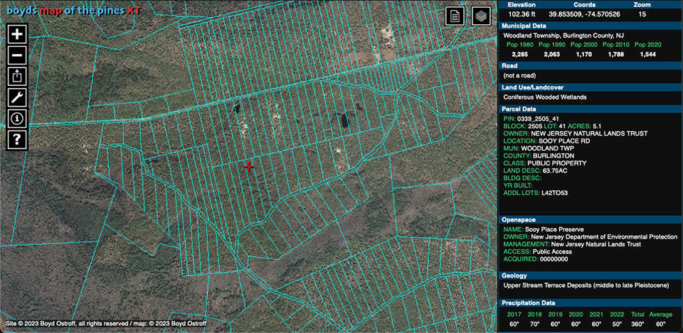
Southern NJ Parcel Boundaries with 2007 Orthoimagery
© 2023 Boyd Ostroff
Data Source
This map is locally hosted at boydsmaps.com
Link to this metadata:
boydsmaps.com/mapinfo/parcels07.html
Link to this map:
boydsmaps.com/#16.00/39.636871/-74.662926/parcels07/0.00/0.00
Originally published:
April 2, 2023
Most recent update:
none
Resolution:
4 feet (1.2 meters)
Map Tiles:
518,000
Size:
32 gb
Description
This map shows tax parcel boundaries overlaid on New Jersey 2007 Natural Color Orthophotography. The 2007 imagery was chosen for its clarity, but of course, conditions on the ground may have changed since then. The maximum resolution of this map is 4 feet/pixel (1.2 meters). 2020 parcel data was used.
Although this map is available in the main boydsmaps app, it was created for the PinesXT app which displays parcel and other data in realtime as you browse the map. You can access PinesXT at any time by clicking the green pine tree button in the main boydsmaps app.
Credits
NJDEP Bureau of GIS, NJ Office of Information Technology, Office of GIS (NJOIT/OGIS)
Distribution Liability
Map software is provided "as-is", without any express or implied warranty. In no event will boydsmaps.com be held liable for any damages arising from the use of this software. The user assumes all risks associated with the use of this software. boydsmaps.com will not be held responsible for any inaccuracies and no responsibility is assumed for damages or other liabilities due to errors, installation, accuracy, availability, use or misuse of the data presented.
NJ 2007 Orthoimagery Metadata
www.arcgis.com/sharing/rest/content/items/4981ffa51aNew Jersey Parcels and MOD-IV data
njogis-newjersey.opendata.arcgis.com/search?collection=Document&q=Parcels