boydsmaps
USGS 1:62500 Historic Topographic Map
© 2023 Boyd Ostroff, Original maps from the USGS Historical Topographic Map Collection
Data Source
This map is locally hosted at boydsmaps.com
 Link to this metadata:
boydsmaps.com/mapinfo/historic62k.html
Link to this map:
boydsmaps.com/#13.00/40.444933/-79.922509/historic62k/0.00/0.00
Originally published:
September 6, 2022
Most recent update:
January 18, 2023
Resolution:
16 feet (4.8 meters)
Map Tiles:
3,500,000
Size:
23 gb
Description
The US Geological Survey has been the primary agency responsible for mapping the United States since 1879 and this new curated collection (available exclusively at boydsmaps.com) includes maps as old as 1884. A total of 1,901 1:62,500 15-minute quadrangles are included (about four million map tiles).
A scale of 1:62,500 (62k) means that objects in the real world are 62,500 times larger than they are on the map. The 15 minute specification refers to the area covered by the map measured in degrees: one degree contains 60 minutes, so 15 minutes is equivalent to 1/4 degree. By comparison, the USGS 24k topo maps have coverage of 7.5 minutes (1/8 degree), so it would take four 24k quadrangles to cover one 62k quad.
Unfortunately, many of the earliest Virginia quadrangles were created at the scale of 1:125,000 (half the scale of a 1:62,500 map). The rather crude level of detail of these quads will be obvious as you zoom in. There were also about 200 quadrangles (primarily in Indiana, Michigan and Ohio) for which no historic map was available at all. These have been cropped from the oldest available 100k topos, most of which date from the 1980's (this is reflected in the table below).
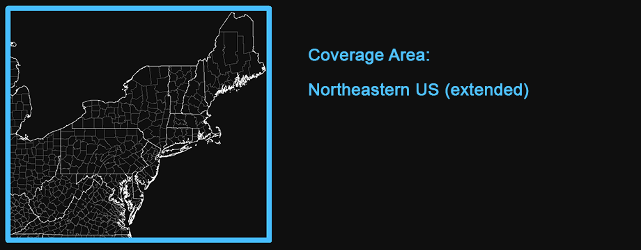
The map includes full coverage of Connecticut, Delaware, Maine, Maryland, Massachussets, New Hampshire, New Jersey, New York, Ohio, Pennsylvania, Rhode Island, Vermont, Virginia and West Virginia with partial coverage of Kentucky, Indiana and Michigan. (This is an ongoing project and coverage will continue to expand in the future).
Original .tif files were downloaded from the Historical Topographic Map Collection, cropped to remove the collar and re-projected as Web Mercator (EPSG: 3857). These source files were processed at a resolution of 4.8 meters/pixel (zoom level 15) which preserves the full detail of the original USGS 300 dot-per-inch scans.
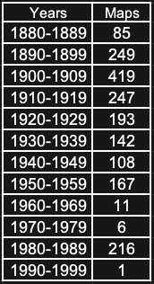
The oldest version of each quadrangle in the USGS archives was used unless there were problems. The following table summarizes the number of maps used from each decade.
The USGS 62k topo maps are shown at zoom levels 12, 13, 14 and 15. Zoom levels 9, 10 and 11 are a mosaic of 86 of the oldest available USGS 250k topo maps, mostly from the 1950's. The contemporary (digital) USGS National Map Topo Basemap is shown at zoom levels 5 through 8.
Resources
See the following USGS document for information about the symbols that are used on USGS topographic maps:
boydsmaps.com/mapinfo/docs/topo_map_symbols.pdf
A USGS document explaining topographic map scales is available here:
boydsmaps.com/mapinfo/docs/topo_map_scales.pdf
Credits
Original maps from the US Geological Survey Historical Topographic Map Collection and National Map Topo Basemap.
www.usgs.gov/core-science-systems/ngp/topo-maps/
basemap.nationalmap.gov/arcgis/rest/services/USGSTopo
Distribution Liability
Although these data have been processed successfully on a computer system at the U.S. Geological Survey, no warranty expressed or implied is made regarding the accuracy or utility of the data on any other system or for general or scientific purposes, nor shall the act of distribution constitute any such warranty. This disclaimer applies both to individual use of the data and aggregate use with other data. It is strongly recommended that these data are directly acquired from a U.S. Geological Survey server, and not indirectly through other sources which may have changed the data in some way. It is also strongly recommended that careful attention be paid to the contents of the metadata file associated with these data. The U.S. Geological Survey shall not be held liable for improper or incorrect use of the data described and/or contained herein.
The digital version of the historical map was georeferenced with a methodology that preserves, but does not exceed, the accuracy of the original map. The historical map product was compiled to meet National Map Accuracy Standards (NMAS) of the era when the map was originally published. Users should be aware that temporal changes may have occurred since this map was originally produced and that some parts of this data may no longer represent actual surface conditions. Users should not use this data for critical applications without a full awareness of its limitations.
Map software is provided "as is", without any express or implied warranty. In no event will boydsmaps.com be held liable for any damages arising from the use of this software. The user assumes all risks associated with the use of this software. boydsmaps.com will not be held responsible for any inaccuracies and no responsibility is assumed for damages or other liabilities due to errors, installation, accuracy, availability, use or misuse of the data presented.