Boydsmaps Elevation Datasets
The following locally-hosted datasets are used to provide realtime display of the elevation at the map crosshairs. The app automatically chooses the highest resolution elevation data available based on your location. Elevation readings are available anywhere within the dataset coverage area(s), regardless of which map you are viewing.
Advanced Spaceborne Thermal Emission and Reflection Radiometer (ASTER) Global Digital Elevation Model (GDEM)
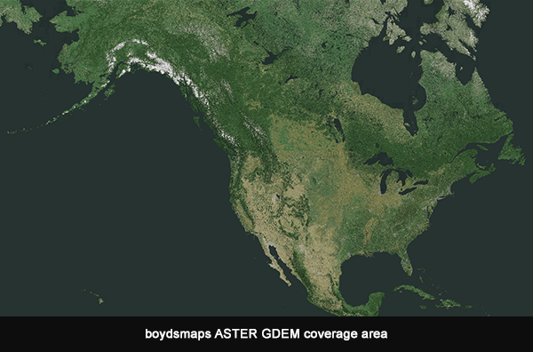
This dataset provides elevation data for locations in North America as indicated below.
Data Source
lpdaac.usgs.gov/products/astgtmv003/
Description
The Advanced Spaceborne Thermal Emission and Reflection Radiometer (ASTER) is an optical instrument aboard the NASA Terra platform, which was launched on December 18, 1999, with data available from 2000 to the present. It consists of three sub-system instruments, visible and near infrared (VNIR), shortwave infrared (SWIR), and thermal infrared (TIR). The VNIR sub-system instrument acquires images in three bands, and the third band includes nadir- and backward-viewing telescopes that allow for creation of Digital Elevation Models(DEMs).
Using stereo imagery from two infrared sensors, ASTER has created a Global Digital Elevation Model (GDEM) at one arc-second resolution. This raw data was processed by boydsmaps at a maximum resolution of 38 meters (about 125 feet).
The ASTER GDEM dataset replaces the older boydsmaps elevation display that requested data from the USGS Elevation Point Query Service (EPQS). The EPQS was never designed to provide realtime streaming data and this often caused errors or unavailability.
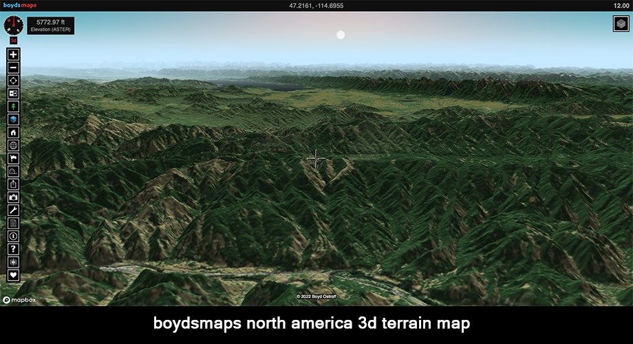
You can visualize this dataset in three dimensions with the North America 3d Terrain map. It was created with ASTER elevation data and Boyd's pseudo-natural coloring derived from the USGS National Landcover Database and European Space Agency Worldcover dataset.
ASTER GDEM Credits
The development of the ASTER GDEM data products is a collaborative effort between National Aeronautics and Space Administration (NASA) and Japan’s Ministry of Economy, Trade, and Industry (METI). The ASTER GDEM data products are created by the Sensor Information Laboratory Corporation (SILC) in Tokyo.
ASTER GDEM Metadata Link
catalog.data.gov/dataset/aster-global-digital-elevation-model-v003High Resolution LIDAR Digital Elevation Model
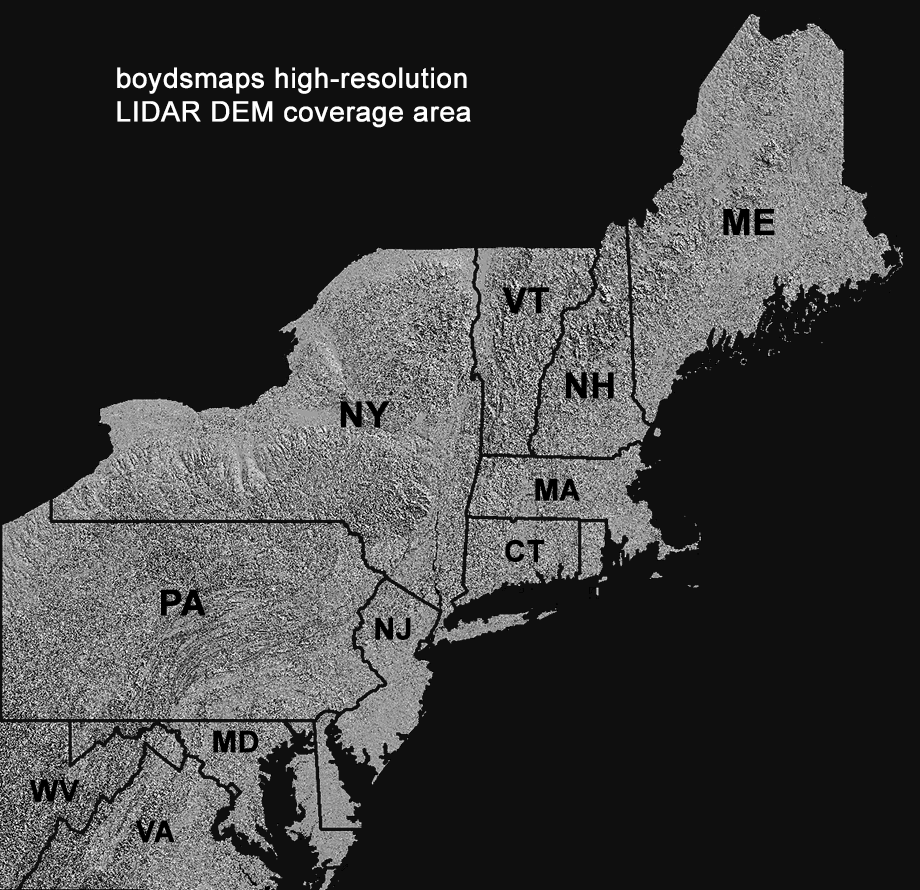
This dataset provides high-resolution elevation data for the Northeastern US region as shown below (New Jersey, New York, Pennsylvania, Maryland, Delaware, Connecticut, Rhode Island, New Hampshire, Vermont and Maine with partial coverage of Virginia and West Virginia).
The dataset was created using DEM data from a variety of sources. Approximately two-thirds of the dataset consists of bare-earth LIDAR data with a horizontal resolution of 1.2 meters (4 feet). Where this was not available, USGS 3DEP 1/9 arc second data was used with a resolution of 2.4 meters (8 feet). In areas where no LIDAR-based DEM was available, legacy USGS NED 1/3 arc second data is used with a resolution of about 9.6 meters (32 feet).
You can visualize the high resolution LIDAR dataset in three dimensions with the Northeast US LIDAR 3d map.
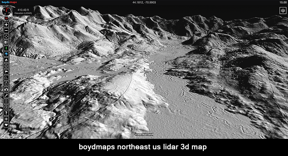
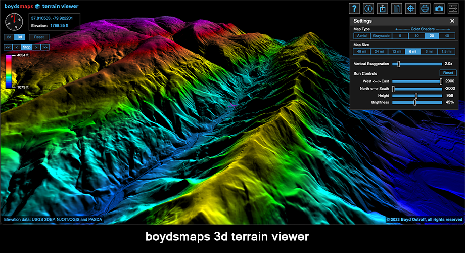
You can explore this dataset in even more detail by clicking the blue cube button in the toolbar which will open the 3d terrain viewer at your current location. (desktop version only). The terrain viewer gives you interactive realtime control over the image rendering parameters.
LIDAR DEM Credits
South NJ 2019 LIDAR, Northwest NJ 2018 LIDAR, Northeast NJ Post-Sandy 2014 LIDAR, Delaware Valley Regional Planning Commission 2015 LIDAR: NJDEP Bureau of GIS, NJ Office of Information Technology, Office of GIS (NJOIT/OGIS)
PAMAP 2008 Statewide 3.2-foot LIDAR: PA Department of Conservation and Natural Resources, Bureau of Topographic and Geologic Survey, PA Spatial Data Access (PASDA)
1-meter LIDAR DEM, 1/9 arc-second LIDAR DEM, 1/3 arc-second legacy DEM: US Geological Survey 3d Elevation Program (USGS 3DEP), USGS National Elevation Database (NED)
LIDAR DEM Metadata Links
njgin.nj.gov/njgin/edata/elevation www.pasda.psu.edu/uci/DataSummary.aspx? pubs.usgs.gov/tm/11/b07/tm11-b7 data.usgs.gov/datacatalog/data/USGS:40e52270 data.usgs.gov/datacatalog/data/USGS:3a81321bDistribution Liability
Map software is provided "as is.", without any express or implied warranty. In no event will boydsmaps.com be held liable for any damages arising from the use of this software. The user assumes all risks associated with the use of this software. boydsmaps.com will not be held responsible for any inaccuracies and no responsibility is assumed for damages or other liabilities due to errors, installation, accuracy, availability, use or misuse of the data presented.