


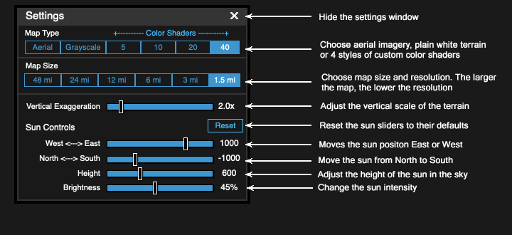
| Vertical Exaggeration | 2 |
| West <---> East | -200 | |
| North <---> South | -900 | |
| Height | 250 | |
| Brightness | 100% |

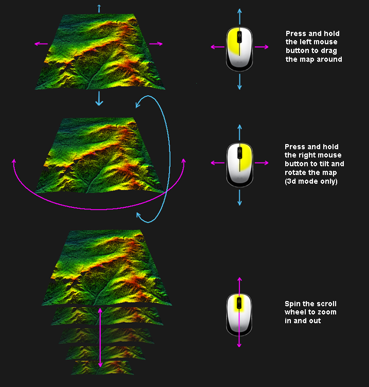
Using the mouse to manipulate the map in three dimensions


boydsmaps.com ("the site") is owned and operated by Boyd Ostroff ("management") and access is only granted for personal, non-commercial, non-institutional use. Use of the site is free, but it is not open source software. Unless noted otherwise, all computer code, maps and other content on the site are copyright © 2023 by Boyd Ostroff with all rights reserved.
The site is provided "as-is", without any express or implied warranty. The maps and data displayed on the site are not survey grade, have not been approved by any government agency and absolutely no claims are made with regard to their accuracy. The user acknowledges that this is experimental, beta software which may not always function properly or reliably, sometimes displaying incorrect data. Use the site at your own risk. In no event will management be held liable for any damages arising from use of the site. Management will not be held responsible for any map, data or code errors and no responsibility is assumed for damages or other liabilities due to availability, accuracy, cybersecurity, use or misuse of the site and its content.
It is the sole responsibility of the user to independently determine the accuracy and suitability of the maps and data on the site before using them for any purpose.
boydsmaps.com does not collect any personally identifiable information and does not share data with any other parties. The site is privately-owned, not affiliated with any company or organization and has no advertising partners or sponsors. We don't sell anything and haven't accepted contributions from anyone. Since there are no user accounts or registration, we simply don't have any of your personal information.
When you access maps and elevation data, your browser requests a series of tiles from the boydsmaps server. These tiles are logged along with the IP address that requested them. There are numerous ways to obscure your real IP address if you're concerned about privacy.
Data from the logfile at boydsmaps.com is aggregated and used to better understand site usage patterns. This data is only available to the site owner, is not used for marketing purposes and is not shared with any third parties.
boydsmaps.com uses the localstorage API to save user preferences in your browser on your device. This data is only accessible by you and no data is sent to or stored on the boydsmaps server. Default settings are the only data items stored on your computer by the terrain viewer. These preferences are set in the dialog box each time you open the Terrain Viewer by clicking the cube button in the main boydsmaps web app. The main boydsmaps app saves a number of other items on your device, see the App Info screen on the main app for details. Nevertheless, the boydsmaps privacy policy is the same across all apps and sites. We do not collect or share any private information.
The site uses the open source Maptalks API to download tiled elevation data and aerial imagery. Maptalks is licensed under the BSD 3-Clause "New" or "Revised" License as follows:
Maptalks is copyright © 2016, maptalks, All rights reserved. Redistribution and use in source and binary forms, with or without modification, are permitted provided that the following conditions are met:
* Redistributions of source code must retain the above copyright notice, this list of conditions and the following disclaimer.
* Redistributions in binary form must reproduce the above copyright notice, this list of conditions and the following disclaimer in the documentation and/or other materials provided with the distribution.
* Neither the name of maptalks.js nor the names of its contributors may be used to endorse or promote products derived from this software without specific prior written permission.
THIS SOFTWARE IS PROVIDED BY THE COPYRIGHT HOLDERS AND CONTRIBUTORS "AS IS" AND ANY EXPRESS OR IMPLIED WARRANTIES, INCLUDING, BUT NOT LIMITED TO, THE IMPLIED WARRANTIES OF MERCHANTABILITY AND FITNESS FOR A PARTICULAR PURPOSE ARE DISCLAIMED. IN NO EVENT SHALL THE COPYRIGHT OWNER OR CONTRIBUTORS BE LIABLE FOR ANY DIRECT, INDIRECT, INCIDENTAL, SPECIAL, EXEMPLARY, OR CONSEQUENTIAL DAMAGES (INCLUDING, BUT NOT LIMITED TO, PROCUREMENT OF SUBSTITUTE GOODS OR SERVICES; LOSS OF USE, DATA, OR PROFITS; OR BUSINESS INTERRUPTION) HOWEVER CAUSED AND ON ANY THEORY OF LIABILITY, WHETHER IN CONTRACT, STRICT LIABILITY, OR TORT (INCLUDING NEGLIGENCE OR OTHERWISE) ARISING IN ANY WAY OUT OF THE USE OF THIS SOFTWARE, EVEN IF ADVISED OF THE POSSIBILITY OF SUCH DAMAGE.
The site uses data in the Mapbox RGB elevation format. Code from the Mapbox GL JS API is not actually used on the site however and no Mapbox elevation data is used. Mapbox GL JS 2.0 is Copyright © 2020, Mapbox, all rights reserved.
boydsmaps.com made its debut in January 2013 and has undergone many changes over the years. It currently consists of the main boydsmaps web app and several smaller, more specialized sites that are accessed as tools from the main app. The 3d Terrain Viewer is the newest of these, launching on June 9, 2023.
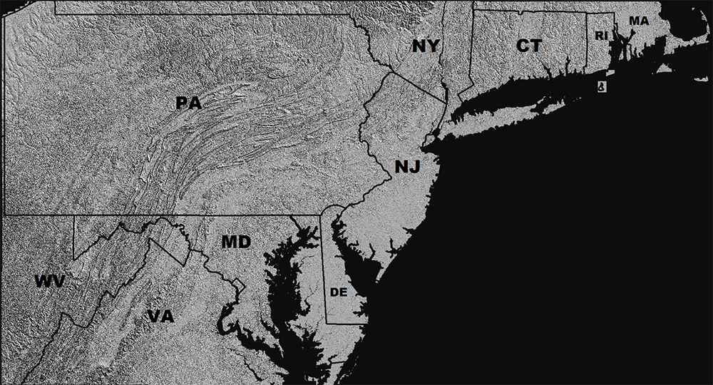
Work on a 3d map viewer began in 2019 and in January, 2020 an experimental site named lidar.boydsmaps.com was launched. That site had limited appeal and was short-lived due to its very small coverage area, which was difficult to expand because it depended hand-made maps in a proprietary format. But that software now forms the core of the Terrain Viewer user interface, while the other code has been completely re-written to use the boydsmaps Mid-Atlantic LIDAR Digital Elevation Model (DEM) dataset which covers about 175,000 square miles in 10 states. Work continues on this dataset and full coverage of New York, Massachussetts, New Hampshire, Vermont and Maine is coming in late summer 2023.
In January 2021, boydmaps.com had about 80 gigabytes of locally-hosted map data. Today we have over 1 terabyte of locally-hosted maps and that will grow to 2 terabytes in the coming months with the expansion of the elevation dataset in addition to added coverage for the USGS Legacy and Historic topo maps.
This map is locally hosted at boydsmaps.com
This is boydsmaps-cached version of the USGS National Map aerial imagery as of May, 2023. The imagery is primarily from the National Agriculture Imagery Program (NAIP). The original imagery was acquired at 1 meter pixel resolution in "leaf-on" (eg: summer) conditions, however this dataset has been processed at 2.4 meter (about 8 ft) resolution. Collection of NAIP imagery is administered by the U.S. Department of Agriculture's Farm Service Agency (FSA).
The map includes full coverage of New Jersey, Pennsylvania, Maryland, Delaware, Connecticut and Rhode Island with partial coverage of Virginia, West Virginia, New York and Massachussets. This is an ongoing project and coverage will be expanded to a larger area in the future.
National Agriculture Imagery Program, US Department of Agriculture, Farm Service Bureau Aerial Photography Field Office, US Geological Survey National Geospatial Technical Operations Center
None. Acknowledgement of the originating agencies would be appreciated in products derived from these data.
Although these data have been processed successfully on a computer system at the U.S. Geological Survey, no warranty expressed or implied is made regarding the accuracy or utility of the data on any other system or for general or scientific purposes, nor shall the act of distribution constitute any such warranty. This disclaimer applies both to individual use of the data and aggregate use with other data.
The dataset was created using DEM data from a variety of sources. Most of the dataset consists of bare-earth LIDAR data with a horizontal resolution of 1.2 meters (~4 feet). Where this was not available, USGS 3DEP 1/9 arc second data was used with a resolution of about 3 meters (~10 feet). In areas where no LIDAR-based DEM was available, legacy USGS NED 1/3 arc second data is used with a resolution of about 10 meters (~33 feet).
South NJ 2019 LIDAR, Northwest NJ 2018 LIDAR, Northeast NJ Post-Sandy 2014 LIDAR, Delaware Valley Regional Planning Commission 2015 LIDAR: NJDEP Bureau of GIS, NJ Office of Information Technology, Office of GIS (NJOIT/OGIS)
PAMAP 2008 Statewide 3.2-foot LIDAR: PA Department of Conservation and Natural Resources, Bureau of Topographic and Geologic Survey, PA Spatial Data Access (PASDA)
1-meter LIDAR DEM, 1/9 arc-second LIDAR DEM, 1/3 arc-second legacy DEM: US Geological Survey 3d Elevation Program (USGS 3DEP), USGS National Elevation Database (NED)
The boydsmaps proprietary shader code starts by finding the minimum and maximum elevations of the map, then dividing that range into 5, 10, 20 or 40 equal groups, depending on the number of colors you choose. The color of each of the 4.2 million pixels in the map is computed based on its position within this scale, such that a smooth transition is made between colors.

Map software is provided "as is", without any express or implied warranty. In no event will boydsmaps.com be held liable for any damages arising from the use of this software. The user assumes all risks associated with the use of this software. boydsmaps.com will not be held responsible for any inaccuracies and no responsibility is assumed for damages or other liabilities due to errors, installation, accuracy, availability, use or misuse of the data presented.