2000's NAPP and Other Monochrome Orthoimagery
© 2024 Boyd Ostroff
This map is hosted locally at boydsmaps.com
Link to this metadata:
boydsmaps.com/mapinfo/bw2000.html
Link to this map:
boydsmaps.com/#14.00/40.616878/-74.825511/bw2000/0.00/0.00
Originally published:
December 31, 2023
Most recent update:
December 18, 2024
Resolution:
4 feet (1.2 meters)
Map Tiles:
4,651,000
Size:
34.2 gb
Data Sources
NJ Office of Information Technology, Office of Geographic Information SystemsDescription
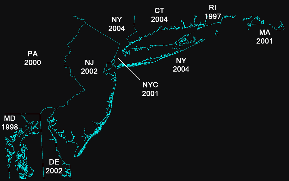
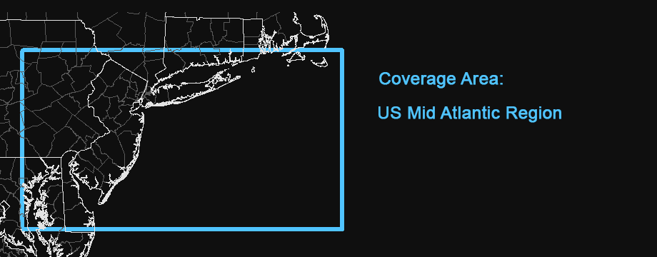
This map features monochrome aerial imagery of the US Mid-Atlantic region, captured between 1997-2004. The imagery comes from a variety of sources in the individual states as well as the USGS National Aerial Photography Program (NAPP). This is a work in progress and coverage will be expanded to a larger area in the future.
Approximate imagery dates are shown below, however there are some relatively small gaps in coverage that were filled with imagery from other periods. The Pennsylvania 2000 NAPP imagery only covered the Eastern part of the state, NAIP 2004 aerials were used in the Western and Southern Pennsylvania area. There were two small areas in Central/Northern New Jersey with no coverage in the 2002 aerials, these were filled with 2006 USDA/NAIP imagery. There are other small gaps in other states where supplemental imagery was used.
In selecting the imagery from each state, the goal was to remain as close as possible to the year 2000.
The source data consists of a mixture of monochrome, color and infrared imagery. This map has been processed as 8-bit monochrome for consistency and clarity. The resolution of the original imagery varies from as low as 8 feet/pixel (2.4 meters) to as high as 1 foot/pixel (30 centimeters). The final map was processed at a resolution of 4 feet/pixel (1.2 meters), which captures the full detail in most of original imagery.
Note: this map replaces the previous Southern New Jersey 2002 aerials, which had limited coverage.
Credits
The New Jersey 2002 high resolution orthophotography project was planned, initiated, and primarily funded by the NJ Office of Information Technology. Additional state funding was obtained from the NJ Department of Transportation and NJ Transit. The U.S. Geological Survey (USGS) and the Natural Resources Conservation Service (NRCS) also contributed federal funding. Imagery was captured by BAE Systems ADR and subcontractors.
New York State GIS Clearinghouse, New York State Digital Orthoimagery Program (NYSDOP), NYS ITS GIS Program Office, NYS ITS Geospatial Services
NYC Dept of City Planning, New York State Statewide Digital Orthoimagery Program, New York City Department of Information Technology and Telecommunications (DoITT) GIS group
Pennsylvania Spatial Data Access (PASDA), USGS National Aerial Photography Program (NAPP), USDA National Agriculture Imagery Program (NAIP)
Connecticut Department of Environmental Protection, Connecticut Environmental Conditions Online
Maryland Department of Information Technology, Maryland Geographic Information Office, Maryland iMap
State of Delaware, Delaware Department of Technology and Information
Rhode Island Geographic Information System (RIGIS), Rhode Island Department of Transportation, Intermap Corporation, National Grid USA
Massachusetts Bureau of Geographic Information (MassGIS), Massachusetts Department of Transportation, Keystone Aerial Surveys, Inc, Intermap Technologies, Charles H. Sells, Inc
Distribution Liability
Although these data have been processed successfully on a computer system at the U.S. Geological Survey no warranty expressed or implied is made by the USGS regarding the utility of the data on any other system, nor shall the act of distribution constitute any such warranty.
The State of New Jersey provides the data set “as is”. The State makes no guarantee or warranty concerning the accuracy of information contained in the data. Also, the State makes no warranty, either expressed or implied, regarding the condition of the product or its fitness for any particular purpose. The burden for determining fitness for use lies entirely with the user. Although these data files have been processed successfully on computers at the State, no warranty is made by the State regarding the use of the data on any other system, nor does the fact of distribution constitute or imply such a warranty.
The State of Delaware makes no warranty or representation, expressed or implied, with respect to the quality, content, accuracy, completeness, currency, or non-infringement of proprietary rights, of any of the GIS or other data or information, or any other materials and items, that are displayed or made available for download from this site. All such data, information, items and materials (collectively, the “FirstMap Data”) are provided "as is" and users are fully and solely responsible for any consequences of use.
The Spatial Data, and the information therein, (collectively the "Data") is provided "as is" without warranty of any kind, either expressed, implied, or statutory. The user assumes the entire risk as to quality and performance of the Data. No guarantee of accuracy is granted, nor is any responsibility for reliance thereon assumed. In no event shall the State of Maryland be liable for direct, indirect, incidental, consequential or special damages of any kind. The State of Maryland does not accept liability for any damages or misrepresentation caused by inaccuracies in the Data or as a result to changes to the Data, nor is there responsibility assumed to maintain the Data in any manner or form. The Data can be freely distributed as long as the metadata entry is not modified or deleted. Any data derived from the Data must acknowledge the State of Maryland in the metadata.
Although this data set has been used by the State of Connecticut, Department of Environmental Protection, no warranty, expressed or implied, is made by the State of Connecticut, Department of Environmental Protection as to the accuracy of the data and or related materials. The act of distribution shall not constitute any such warranty, and no responsibility is assumed by the State of Connecticut, Department of Environmental Protection in the use of these data or related materials. The user assumes the entire risk related to the use of these data.
These data were created for informational, planning and guidance use only. They are a general reference, not a legally authoritative source for the location of natural or manmade features. Proper interpretation of these data may requre the assistance of appropriate professional services. The cartographic representations depicted have not been verified by a RI Registered Professional Land Surveyor and are not intended to be used in place of a survey. The producer makes no warranty, express or implied, related to the accuracy, reliability, completeness, or currentness of these data.
Map software is provided "as is", without any express or implied warranty. In no event will boydsmaps.com be held liable for any damages arising from the use of this software. The user assumes all risks associated with the use of this software. boydsmaps.com will not be held responsible for any inaccuracies and no responsibility is assumed for damages or other liabilities due to errors, installation, accuracy, availability, use or misuse of the data presented.